|
 Lat 12� 47�N
Long 044� 58�E
Time
Zone GMT +3 Lat 12� 47�N
Long 044� 58�E
Time
Zone GMT +3
Port
limits
All the sea area north of
a line from Round Island to a position 12.5 cables on a
bearing 198� from Round Island to Latitude 12� 44.0�N, 45�
00�E, thence 6.3 nm on a bearing of 267� to Ras Abu Qiyamah.
Sea
buoys, fairways and channels
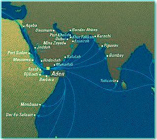
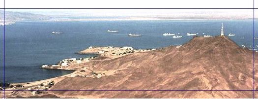
The Aden and Little Aden
peninsulas are very prominent, with the harbour between them.
Approaching from the W, pass 1 nm south of Little Aden
Peninsula and then to the entrance to the dredged channel at
12� 44.5� N, 044� 57� E marked by the No. 1 buoys (QR
and QG). At
night, with Elephant�s Back light (red and white sectored)
on a bearing of not greater than 061� (white sector) a ship
will clear the Little Aden Peninsula on a course to bring her
close to the port entrance.
Approaching from the E,
pass 1 nm south of the Aden Peninsula and then to the channel
entrance. At
night, pass 1.5 nm S of Ra�s Marshaq light and then steer W
to the entrance to the channel.
From the No. 1 buoys, the
two harbours are approached by a dredged channel 16.0 m in
depth, width 220 m.
From the bifurcation point, the channel to Little Aden
oil harbour has a depth of 14.7 m, width 220 m, length 2.3 nm,
marked by pairs of buoys. Vessels should proceed mid-way between these buoys, and
immediately after passing No. 2 buoys, turn to head 300� on
the leading marks for the centre of the channel to pass north
of the oil harbour breakwater.
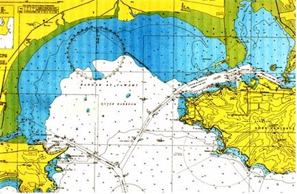
Aden inner harbour is
approached by the same dredged channel, which divides at Buoy
No. 3 (S Cardinal), 9 cables north of the channel entrance. From this point, the inner harbour channel has a depth
of 15.0 m, width 185 m and is 2.6 nm to the inner harbour
breakwater.
Vessels
proceed on a course of 027� to pass between No. 2 Buoys, then
on a heading of 047� between the channel buoys to clear the
inner harbour breakwater.
The 15.0 m deep dredged channel in the inner harbour is
220 m wide and leads, on a heading of 068�, to the 700 m
diameter turning area off the ACT.
Ships proceeding to Ma�alla should then pass from the
south side of the turning area between buoys Nos 9 starboard
and 9 port.
Pilot
Pilotage is compulsory for
all vessels over 200 GRT entering or leaving (with certain exceptions). 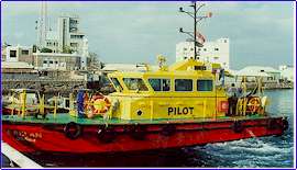 The
pilot station for the oil harbour and for deep draft vessels
bound for the inner harbour is at the channel entrance.
The pilot station for other vessels proceeding to the
inner harbour is by No. 1 buoys 9 cables NNE of the point
where the oil harbour and inner harbour channels divide.
The
pilot station for the oil harbour and for deep draft vessels
bound for the inner harbour is at the channel entrance.
The pilot station for other vessels proceeding to the
inner harbour is by No. 1 buoys 9 cables NNE of the point
where the oil harbour and inner harbour channels divide.
All vessels arriving off
the port and wishing to enter must show the standard
international signal to request a pilot.
Pilot boats have red hulls and yellow superstructures.
They exhibit the standard international pilot signal at
night. A
pilot ladder should be rigged on the port side by the ship
during the NE Monsoon period (mid-September to May).
During the SW monsoon (June to mid-September), pilot
ladders should be rigged on the port side for ships
approaching from the W and on the starboard side for ships
approaching from the E. period (mid-September to May).
During the SW monsoon (June to mid-September), pilot
ladders should be rigged on the port side for ships
approaching from the W and on the starboard side for ships
approaching from the E.
Anchorage
Anchorage areas are
available for ships in the outer harb, with depths of from 6
to 20 meters in good holding ground.
Anchorage areas are not marked on the chart at present.
Smaller vessels can anchor to the north of the oil
harbour approach channel and west of the inner harbour
approach channel. Vessels
with a draft of ten meters or more can anchor to the south of
the oil harbour approach channel and west of the approach
channel to both harbours.
Anchorage is prohibited within a radius of 5 cables of
the channel entrance and within
2 cables of any port approach channel.
Vessels are warned that
many disused cables exist in the area between Ras Tarshayn and Jazirat Salil.
A fiber-optic cable is laid from south of the port
entrance to the shore (see Admiralty Chart No. 7).
A yacht anchorage is available in the inner
harbour between the Prince of Wales/Abkhari Pier and the
dolphin oil berth north of this.
Large yachts may anchor in the anchorage south of the
western end of the rubble mound.
|